heyya i used to do maps, and im wondering about making heightmaps. im wondering what the best way to create a heightmap that i control.
i want control over where hills and rivers are....
however i want to watch my poor sketches start to look realistic.
im wondering. whats the most common method/program used. im good with photoshop (though my draw pad/pen thing no longer works =/ ) and halfway through learning 3DS Max. which could make a heightmap with a little research..
i used to use photoshop before i was really good with it.. (hence never releasing a map) =p but now im good with other programs i wanna give it another go....
(p.s. sorry i would of posted logically in the "map" section but computer says no =p)
heightmap
Moderator: Moderators

-
Dead.Rabit
- Posts: 264
- Joined: 03 Sep 2005, 04:28

-
Dead.Rabit
- Posts: 264
- Joined: 03 Sep 2005, 04:28
i was going to use DEM files, but i cant convert them...
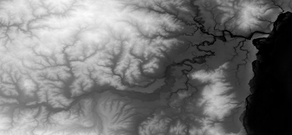
this is a scaled down DEM and kind of what im trying to achieve
EDIT: heh i was going to post in maps, but its access denied... i guess its just for map releases nowadays... or just a lil gang of people who stream out maps... which im never really gonna do.. only when i get inspiration =]
D.R
this is a scaled down DEM and kind of what im trying to achieve
EDIT: heh i was going to post in maps, but its access denied... i guess its just for map releases nowadays... or just a lil gang of people who stream out maps... which im never really gonna do.. only when i get inspiration =]
D.R
Last edited by Dead.Rabit on 15 Oct 2006, 00:45, edited 1 time in total.
I think its bryce or some... thing..
This should help
http://taspring.clan-sy.com/phpbb/viewtopic.php?t=3941
This should help
http://taspring.clan-sy.com/phpbb/viewtopic.php?t=3941


