And I've gotten some stuff done. I used Beherith's WIC editor texture/height mapping guide. That was all great.
The map that I'm making is just a rough draft, really. I didn't want to do a whole bunch of work tweaking the map only to find out that I did something incorrectly. But I got the general layout.
Oh, and a general question about the WIC editor. The scale in the editor is 0-128, but in spring we can obviously go further both negatively and positively. How do I know what the scale will be when I transfer over to spring? Will 1 in WIC equal 5 in spring or what?
However, I'm rather stuck now. Here's what I have so far for a 16x16 map (you can open all of these with GIMP):
-A 8192x8192 .xcf full texture map:
http://www.filedropper.com/compilation
-A 512x512 .tga small texture map:
http://www.filedropper.com/texturemap
-A 513x513 .tga height map (greyscale, 1 layer):
http://www.filedropper.com/heightmapimage
-A 512x512 .tga metal map (6x6 pixel squares of 255 red) I'm aware this should be 1024x1024 for a 16x16 map, so I can change it later.:
http://www.filedropper.com/metalmap
A .png screenshot of the map from above and from within the WIC editor just so you know what it would ideally look like:
http://www.filedropper.com/aboveview
I was trying to move on, but I've run into several walls. First, a lot of the stuff on the wiki is either A) outdated or B) links to outdated things
I went looking around and found Beherith's up-to-date mapconv, and it specifies things differently than what's in the wiki.
Feature Map
So, I haven't made a feature map yet because I don't know what is right and what is wrong. I read something about 0-255 blue being grass, green being trees, and I think 0-254 red being features. What is correct?
Also, what's with fs.txt? I put a list of features in there, but where do I get the names from? I've looked at a feature pack of 28 trees, and there were a bunch of items in the objects3d folder. Would the objects3d folder reside in my mapconv folder? Then, would I put fs.txt in mapconv? Would I simply take the names in the objects3d folder and list them in fs.txt?
From what I read, the top of the list is 254 (or 255? not sure) red, and it goes down as you go down the list.
Also, should the background of my feature map be black or white?
MapConv Compiling
I've since then found Beherith's new mapconv. I ran the example.bat and I'm looking at a bunch of things.
I see a bunch of different command extensions for the maps where I can specify all sorts of fun things like min/max map height and such.
Now, my guess is that I have to make a .bat file where I specify all this stuff. I can't really tell how to use MapConv.exe.
Honestly, this whole mapconv thing confuses me completely despite what I've read.
SMD Compiling
I also know that I have to take the .smf file that is generated and then make it into a .smd file by writing a program. I've seen stuff that looks like the stuff here: http://springrts.com/wiki/Maps:SMD However, I haven't got a clue how to make that work. Do I just copy that stuff into a text file, edit whatever parameters I'd like, rename it .bat, and then run it? I really don't know.
Thanks for any help.
EDIT: If you're curious about the map that I'm making, I'll tell you about the idea behind it. Theoretically, anything with a deep blue texture on the map is deep water. You can build any sea building in those pools.
Where there is water but still sand texture, anything can walk through it and a large number of things can fire while standing in it. You can build harpoons, floating lasers, etc...but no factories. So the shallow pools aren't really obstacles so much as different types of terrain, whereas deep water is a true block to anything not amphib.
Here are a few of the goals I had in mind:
-encourage and reward the use of innovative strategy
-encourage moderate mobility rather than porcing
-make it difficult or at least a bad idea to porc up a portion of the map, but easy to make small offensive/defensive outposts
-Allow and support many methods of attack (veh, kbot, seaplane, hovers, ships)
-mexes under the water in various pools
-regarding choke points, have a few...but not too porcable
-make starting positions have an average amount of metal when compared to the map as a whole
-encourage seaplane usage by putting mexes underwater. seaplanes are the only way to upgrade underwater mexes in shallow pools, and the only way that makes sense in the deep pools (who's going to build a T2 shipyard in a small pool? They might, but it won't be common)
-make tidal somewhat poor because pools do not flow much...around 10-13
-make wind very good around 10-25 because there is very little room on land to build
-DISCOURAGE THE USE OF T2 SHIPS - too powerful vs land units - done by very small deep poles
-Allow and slightly encourage the use of T1 ships if they invest M into a shipyard (so you building the shipyard is good defensively, but not offensively)
-the terrain should be largely flat, with mountains/hills being exceptional features
-reward players for doing things that they normally wouldn't want to do! (seaplanes, hovers, using ships to fight against land, etc)
-emphasize the utility of aquatic features on a mostly land map
I would also have a fairly large number of trees near the central pool to encourage players to mobilize fairly quickly. There is more land in the middle of the map than anywhere else, so hopefully that also gets people out front ASAP because otherwise expansion will be very difficult.
The cliffs are a sort of built in balance. The idea is that even if you lose the land in front of you (between the cliff and the pool in the center of the map), you can still clear out enemies by firing down from the cliff. So while you may have lost your half of the center, the enemy will not have gained your half. Thus you don't totally lose the game if you lose your center portion.
So, I've been making something along those lines. Ideally the map would be for 4v4, though 6v6 could be comfortable, and 8v8 would be a tight squeeze.
At the moment, I'm not even sure if the terrain is very navigable, but that'll come later in the tweaking when I figure out that I've done some of the first steps correctly.
So, I'm making my first map...
Moderator: Moderators

Re: So, I'm making my first map...
Different imagehost please, captcha just to view a picture is annoying.
imageshack, abload or something.
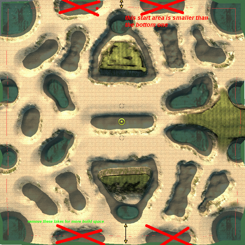
Your map layout looks cool.
Two small notes: http://www.abload.de/img/mapowxb.jpg
been a while since i tried mapping so iam no expert:
So just make a .txt file in the mapconv.exe folder, rename to .bat and copy all your mapfiles there.
In the .bat goes something like copied from:
http://springrts.com/phpbb/viewtopic.php?f=56&t=21458
Then run the .bat by doubleclick.
The .smf does not have to be changed anymore, its just that the .smd file has to have the same name.
The .bat is only for the mapconv programm so you do not have to type the parameter list again and again if you change something.
Probally best to unzip a finished map and use its .smd file. If you want for example the metal extractor settings of DSD but like the lighting of Nuclear Winter you could just replace the section [LIGHT] section.
Depending on them, the same heightmap could be totally flat or a mountain range. Only way to find what looks good, is to test...
Features: No idea, never got them to work. Seems a little more complicated while doing a map without feature is not that difficult even though it does still include messing around with many strange files
imageshack, abload or something.
Your map layout looks cool.
Two small notes: http://www.abload.de/img/mapowxb.jpg
Yes, might be too little land to build stuff and navigate. As a 10x10 1v1/2v2 map it might work. Try to get it working in spring asap even if the texture is not finished or whatever. You might be surprised how it looks ingame...Useless if you do a nice texture and then you can not place buildings anywhere because the terrain is too bumpy or something.At the moment, I'm not even sure if the terrain is very navigable
been a while since i tried mapping so iam no expert:
basically you have to run mapconv.exe with the right parameters like all your .bmp and some numbers that define how high/low mountains will be. Also some parameters how much to compress the textures or something.Now, my guess is that I have to make a .bat file where I specify all this stuff. I can't really tell how to use MapConv.exe.
Honestly, this whole mapconv thing confuses me completely despite what I've read.
So just make a .txt file in the mapconv.exe folder, rename to .bat and copy all your mapfiles there.
In the .bat goes something like
Code: Select all
MapConv -i -c 0 -x 250 -n 25 -o Zion_v1.smf -t t.bmp -a h.raw -m m.bmp -f f.bmphttp://springrts.com/phpbb/viewtopic.php?f=56&t=21458
Then run the .bat by doubleclick.
I think you got things a little confused here. Afaik the .smd is just a textfile that defines some things, like startlocations. Its not a program and does not have to be renamed to .batSMD Compiling
I also know that I have to take the .smf file that is generated and then make it into a .smd file by writing a program. I've seen stuff that looks like the stuff here: http://springrts.com/wiki/Maps:SMD However, I haven't got a clue how to make that work. Do I just copy that stuff into a text file, edit whatever parameters I'd like, rename it .bat, and then run it? I really don't know.
The .smf does not have to be changed anymore, its just that the .smd file has to have the same name.
The .bat is only for the mapconv programm so you do not have to type the parameter list again and again if you change something.
Probally best to unzip a finished map and use its .smd file. If you want for example the metal extractor settings of DSD but like the lighting of Nuclear Winter you could just replace the section [LIGHT] section.
High/low contrast is set by some number parameters of mapconv.How do I know what the scale will be when I transfer over to spring? Will 1 in WIC equal 5 in spring or what?
Depending on them, the same heightmap could be totally flat or a mountain range. Only way to find what looks good, is to test...
Features: No idea, never got them to work. Seems a little more complicated while doing a map without feature is not that difficult even though it does still include messing around with many strange files
Re: So, I'm making my first map...
Hey thanks a lot, that really helps out.
I think I agree with your edit suggestion. I'll probably edit it eventually, after I test out everything.
If anyone could comment on features, that would be nice.
Otherwise, I'll see how far this gets me. Thanks!
I think I agree with your edit suggestion. I'll probably edit it eventually, after I test out everything.
If anyone could comment on features, that would be nice.
Otherwise, I'll see how far this gets me. Thanks!

Re: So, I'm making my first map...
On features:
255 green is geo
blue is grass
201-216 are spring default trees
Red is stuff from the fs.txt
Put fs.txt next to mapconv
Open up the feature .tdf files with a text editor (from the features directory in feature packs) and look at their names, like [btreeblo-1] or [artOakSmallLo]
Add their names to fs.txt:
The -1 added after the name of each feature tells my mapconv to randomly rotate every single instance of said feature.
Also, from the newer feature packs, use the trees marked as 'hi' sparingly, since they are indeed high poly and will reduce frame rate.
Now, you can specify which feature you want in the red channel:
255 red is artBirchBigLo
254 red is artBirchMediumLo
etc
255 green is geo
blue is grass
201-216 are spring default trees
Red is stuff from the fs.txt
Put fs.txt next to mapconv
Open up the feature .tdf files with a text editor (from the features directory in feature packs) and look at their names, like [btreeblo-1] or [artOakSmallLo]
Add their names to fs.txt:
Code: Select all
artBirchBigLo -1
artBirchMediumLo -1
artBirchOldLo -1
artBirchSmallLo -1
artMapleBasicLo -1
artMapleBigLo -1
artMapleOldLo -1
artMapleTallLo -1
artMapleYoungLo -1
artOakBasicLo -1
artOakBasicVarLo -1
artOakBigLo -1
artOakGrandLo -1
artOakOldLo -1
artOakTallLo -1
artOakYoungLo -1
artBush1Lo -1
artBush2Lo -1
artBush3Lo -1Also, from the newer feature packs, use the trees marked as 'hi' sparingly, since they are indeed high poly and will reduce frame rate.
Now, you can specify which feature you want in the red channel:
255 red is artBirchBigLo
254 red is artBirchMediumLo
etc
Re: So, I'm making my first map...
Thanks behe for the feature info. I'll look at that soon. I want to get these basics working first.
Ok, so I got really far! I used mapconv and it compiled. I modified the .smd from small supreme battlefield v2 to my cause (edited a few parameters and deleted the line about DetailTex=). Then I put it all together into a .sd7 file using 7-zip with the settings shown here: http://springrts.com/wiki/Maps:Compiling
There were a few differences between me and that link since I have a new version, but I chose everything as similarly as possible.
However, when I load up spring, the minimap failed to load. Also, when I look on the maplist, it just lists my map as 0x0 and none of the stats are listed (wind, tidal, etc are all 0). I thought it was an error with my .smd file, but I hardly changed it at all!
So I was thinking that I didn't get a correct size or something for one of the .bmp files when I compiled all of them using mapconv. So, here's what I used:
-1024x1024, .bmp, 24-bit, R8G8B8, completely black feature
-8192x8192, .bmp, 24-bit, R8G8B8, texture
-513x513, .bmp, RGB, greyscale, height
-512x512, .bmp, 32-bit, A8R8G8B8, metal
I also found something confusing...in the example.bat in mapconv, it says that the heightmap should be "xsize*64+1 by ysize*64+1". For my map, isn't xsize 1024? And 1024*64 is freaking HUGE. Something is wrong here...help?
Also,
xsize = intex width / 8
But what is intex width? Is that my 8192?
Last edited by gonpost on 01 Mar 2010, 08:40, edited 2 times in total.
Re: So, I'm making my first map...
You have to upscale your heightmap to 1025*1025, use photoshop smooth upscale, and preferably add a -l parameter to mapconv.
xsize is spring size in this case, which is misleading, ill go edit mapconv.
xsize is spring size in this case, which is misleading, ill go edit mapconv.
Re: So, I'm making my first map...
Also, about the goals you had in mind; in my opinion, your overreaching. I think I fell into the same trap with my first map as well, amazon river delta.
Try not to make the same mistakes as I did on that map.
Try not to make the same mistakes as I did on that map.
Re: So, I'm making my first map...
Thanks behe. I'll keep that in mind about overreaching.
Same thing is occuring...this time I used:
-1024x1024, .bmp, 24-bit, R8G8B8, completely black feature
-8192x8192, .bmp, 24-bit, R8G8B8, texture
-1025x1025, .bmp, greyscale, height (upscaled using GIMP's "scale image")
-512x512, .bmp, 24-bit, R8G8B8, metal
My .bat file is:
MapConv -i -c 0 -x 128 -n 0 -o Swamp.smf -t texture.bmp -a height.bmp -m metal.bmp -f feature.bmp -l -q
My .smd is:
Any ideas? I might just have to catch one of you on spring sometime and tell you what I'm doing as I progress.
Same thing is occuring...this time I used:
-1024x1024, .bmp, 24-bit, R8G8B8, completely black feature
-8192x8192, .bmp, 24-bit, R8G8B8, texture
-1025x1025, .bmp, greyscale, height (upscaled using GIMP's "scale image")
-512x512, .bmp, 24-bit, R8G8B8, metal
My .bat file is:
MapConv -i -c 0 -x 128 -n 0 -o Swamp.smf -t texture.bmp -a height.bmp -m metal.bmp -f feature.bmp -l -q
My .smd is:
Code: Select all
[MAP]
{
	Description=Swamp.  Ideally for 4v4.  For best gameplay, use the terrain for an innovative strategy with multiple types of units;
	TidalStrength=12;
	Gravity=100;						//in units/sec^2
	MaxMetal=1.2;						//how much metal a map square with the maximum metal value gives
	ExtractorRadius=180;				//radius that a single extractor(mine) extracts from
	MapHardness=185;

	[ATMOSPHERE]
	{
		FogColor=0.9 0.9 0.9;
		FogStart=0.5;

		CloudColor=0.85 0.7 0.7;
		SkyColor=0.1 0.2 0.9;

		SunColor=1 0.8 0.4;
		CloudDensity=0.2;

		MinWind=10;
		MaxWind=25;
	}
	[WATER]
	{
		WaterBaseColor=0.4 0.7 0.8;  //color at water surface
		WaterAbsorb=0.004 0.003 0.002;  //how fast different colors are absorbed by the water
		WaterMinColor=0.1 0.2 0.3;  //the min value the water colors will go down to
		WaterPlaneColor= 0.1 0.1 0.3;

	}
	[LIGHT]
	{
		SunDir=1 0.7 1;						//direction of sun (spring will normalize it later)(y component is upward)

		GroundAmbientColor=0.4 0.4 0.4;		//ambient (non sun lit) color of ground (and grass trees etc)
		GroundSunColor=0.7 0.7 0.7;			//color of ground where fully sun lit (added to ambient)
		GroundShadowDensity=1;			//how far from the non shadowed to the ambient color stuff in shadow will go

		UnitAmbientColor=0.3 0.3 0.3;		//ambient (non sun lit) color of units (and wreckage etc)
		UnitSunColor=0.8 0.8 0.8;			//color of units where fully sun lit (added to ambient)
		UnitShadowDensity=1;				//how far from the non shadowed to the ambient color stuff in shadow will go

	}
	[TEAM0]
	{
		StartPosX=936;
		StartPosZ=5210;
	}
	[TEAM1]
	{
		StartPosX=7280;
		StartPosZ=2981;
	}
	[TEAM2]
	{
		StartPosX=2787;
		StartPosZ=7564;
	}
	[TEAM3]
	{
		StartPosX=5409;
		StartPosZ=611;
	}

	[TEAM4]
	{
		StartPosX=2460;
		StartPosZ=6202;
	}
	[TEAM5]
	{
		StartPosX=5706;
		StartPosZ=1988;
	}
	[TEAM6]
	{
		StartPosX=62;
		StartPosZ=1638;
	}
	[TEAM7]
	{
		StartPosX=8120;
		StartPosZ=6493;
	}
}
Any ideas? I might just have to catch one of you on spring sometime and tell you what I'm doing as I progress.
Re: So, I'm making my first map...
What is the exact bug?
Black minimap can be solved by deleting mini.bmp and mini.dds before compile.
Any other warnings or errors given by mapconv?
Black minimap can be solved by deleting mini.bmp and mini.dds before compile.
Any other warnings or errors given by mapconv?
Re: So, I'm making my first map...
No warnings. I'll delete those two files and try again. It was just that "the minimap for swamp.sd7 failed to load". Then for all the stats for the map they were all 0 (though tasclient wouldn't even let me actually choose the map...i could just look at it)
Edit: I'm not supposed to do anything with those minimap files, am I? I just leave them in the mapconv folder and don't do a thing with them...
Edit 2:Also, in the description of the map, it says "[string "maphelper/mapinfo.lua"]:69: maps/Swamp.smd: missing file"
Edit3: still no luck
Edit: I'm not supposed to do anything with those minimap files, am I? I just leave them in the mapconv folder and don't do a thing with them...
Edit 2:Also, in the description of the map, it says "[string "maphelper/mapinfo.lua"]:69: maps/Swamp.smd: missing file"
Edit3: still no luck
Re: So, I'm making my first map...
Aha.
That comment gave me a clue. I was looking at other maps, and they all have the files in the maps folder. I think that's the key.
So, I put the 3 .smd, .smf, .smt files in C:/maps
I now right click maps and try to add it to archive. I click add to archive and the screen with all the options pops up. However, when I click ok for it to archive, it says "can not open file".
While I'm here, I want the solid block size to be "non-solid", correct?
Re: So, I'm making my first map...
Interesting.
Well, I simply put all of the files inside of another maps folder which was in my maps folder.
Essentially, C:/maps/maps/filesarehere
Then I archived the last maps folder, and it works! Woot!
Well, I simply put all of the files inside of another maps folder which was in my maps folder.
Essentially, C:/maps/maps/filesarehere
Then I archived the last maps folder, and it works! Woot!
Re: So, I'm making my first map...
You dont need the mini.* files.
Non solid is essential.
Non solid is essential.

Re: So, I'm making my first map...
I was going to suggest same thing, people need room for base building though having to spread your base out along those passages might be interesting as long as it's not bumpy or anything.knorke wrote:Different imagehost please, captcha just to view a picture is annoying.
imageshack, abload or something.
Your map layout looks cool.
Two small notes: http://www.abload.de/img/mapowxb.jpg
Re: So, I'm making my first map...
Yeah, I've played the map with a friend of mine as it is so far. There's actually enough room in the back as it is, surprisingly. The land areas are all very flat. The idea was for all visible land to be build-able on (except for the two cliff slopes on each side).Sausage wrote:I was going to suggest same thing, people need room for base building though having to spread your base out along those passages might be interesting as long as it's not bumpy or anything.knorke wrote:Different imagehost please, captcha just to view a picture is annoying.
imageshack, abload or something.
Your map layout looks cool.
Two small notes: http://www.abload.de/img/mapowxb.jpg
I'll be messing with variables and tweaking a whole bunch of things just to see what happens, so don't expect a finished product for a while yet. I want to understand WHY things occur rather than just taking them all for granted.
I might try making one half of the map and then mirroring it, but then there's not as much character to it.
I'll also be messing with textures and detail textures a lot more, as well as adding in various settings to the .smd file. And of course I'll be changing the metal map because right now it's very, very rough and not what I'd like in a final.
Anywho, thanks again to all of you.
Re: So, I'm making my first map...
So I've been playing around, and I have two questions that I haven't found the answer to.
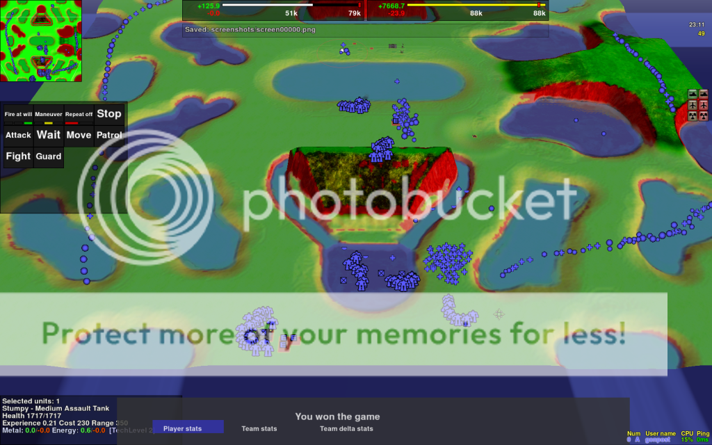
First, look past the edges of the map in this picture.
http://i413.photobucket.com/albums/pp21 ... n00001.png
Does anyone know why there are lines extending from the pools of water on the edge of the map out into infinity? It does this the whole way around and is somewhat annoying.
Second, when I tried using mapconv with the slowest, best quality setting, my map was completely flat when I tried to play it. The range that I specified was -50 to 350 but the entire map was at 327. It's not a big deal because the CUDA mapconv works perfectly, but I'd still like to know if I can fix that problem. And before you ask, the heightmap that I used looked correct. Also, is there really a big difference between the CUDA render and the slowest, best render?
Re: So, I'm making my first map...
Water lines extending is completely normal. Its characteristic of whatever water renderer youre using.
That sounds like a strange bug, never had it before.
Using no options should be almost 0 quality loss compared to highest. Highest is for crazy people (like me). Cuda should work just fine.
That sounds like a strange bug, never had it before.
Using no options should be almost 0 quality loss compared to highest. Highest is for crazy people (like me). Cuda should work just fine.
Re: So, I'm making my first map...
Another question. My grass is not showing up. I've got grass detail on 10.
I painted 1x1 blue pixels (tried both 255 and 150) in various places on the map, but I see no grass...any clue why? All of the rest of the features like palm trees and geos are showing up just fine.
Also, if you know of the top of your head (don't worry if you don't, i'll go find out), what numbers in the .smd would give me lots of light? I don't want a dim map... Here's a reference to jog your memory.
I'm practically done besides these few things. :D
I painted 1x1 blue pixels (tried both 255 and 150) in various places on the map, but I see no grass...any clue why? All of the rest of the features like palm trees and geos are showing up just fine.
Also, if you know of the top of your head (don't worry if you don't, i'll go find out), what numbers in the .smd would give me lots of light? I don't want a dim map... Here's a reference to jog your memory.
Code: Select all
	[ATMOSPHERE]
	{
		FogColor=0.95 0.62 0.45;
		FogStart=0.42;

		CloudColor=0.37 0.22 0.25;
		SkyColor=1 0.76 0.34;

		SunColor=1 0.85 0.75;
		CloudDensity=0.2;

		MinWind=10;
		MaxWind=20;
	}
	[WATER]
	{
		WaterSurfaceColor=0.7 0.64 0.86;
		WaterPlaneColor=0.04 0.16 0.25;
		WaterBaseColor=0.80 1 1;
		WaterAbsorb=0.012 0.0060 0.0045;
		WaterMinColor=0 0 0.05;

	}
	[LIGHT]
	{
		SunDir=0.6 0.85 0.8;
		GroundAmbiantColor=0.09 0.06 0.05;
		GroundSunColor=0.95 0.62 0.45;
		GroundShadowDensity=1;
		UnitAmbiantColor=0.09 0.06 0.05;
		UnitSunColor=0.98 0.68 0.49;
		UnitShadowDensity=1;
		SpecularSunColor=0.95 0.62 0.45;

}-
SirArtturi

- Posts: 1164
- Joined: 23 Jan 2008, 18:29
Re: So, I'm making my first map...
try painting 30x30 brush and see what happens after that :)gonpost wrote:Another question. My grass is not showing up. I've got grass detail on 10.
I painted 1x1 blue pixels (tried both 255 and 150) in various places on the map, but I see no grass...any clue why? All of the rest of the features like palm trees and geos are showing up just fine.
Also, if you know of the top of your head (don't worry if you don't, i'll go find out), what numbers in the .smd would give me lots of light? I don't want a dim map... Here's a reference to jog your memory.
Basically any of these settings will effect on how the light works for the map.
Code: Select all
[LIGHT]
	{
		SunDir=0.6 0.85 0.8;
		GroundAmbiantColor=0.09 0.06 0.05;
		GroundSunColor=0.95 0.62 0.45;
		GroundShadowDensity=1;
		UnitAmbiantColor=0.09 0.06 0.05;
		UnitSunColor=0.98 0.68 0.49;
		UnitShadowDensity=1;
		SpecularSunColor=0.95 0.62 0.45;
As also, I suggest shadowdensity to be something like 0.7 to get smoother shadows.
Re: So, I'm making my first map...
Ah, between that and some more reading, I found what I wanted.
So it's red, green, blue for the 3 numbers. Also, 0 tends towards dark, 1 tends towards white.
I also found that .5 is a great setting for having no fog etc...if you just want things to look normal. If you want to give them some slight definition, go to .3-.4. If you want to give them slight blur, go .6-.7.
As for the grass, I just had to paint several pixels of it for it to show up, so that problem is solved. :)
All I have to do now is maybe get some nice rocks and then add metal textures to all of the mex spots. Muahahaha.